


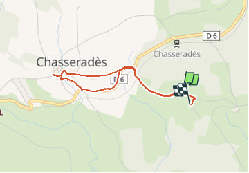
AR Chasserades

PatriceCocuaud
User

Length
3.4 km

Max alt
1181 m

Uphill gradient
47 m
Km-Effort
4.1 km

Min alt
1154 m

Downhill gradient
51 m
Boucle
Yes
Creation date :
2022-08-30 16:30:19.424
Updated on :
2022-08-30 19:20:31.657
52m
Difficulty : Very easy

FREE GPS app for hiking
 SityTrail
IGN / Geographical institutes
SityTrail Plus
The world is yours!
About
Trail Walking of 3.4 km to be discovered at Occitania, Lozère, Mont Lozère et Goulet. This trail is proposed by PatriceCocuaud.
Positioning
Country:
France
Region :
Occitania
Department/Province :
Lozère
Municipality :
Mont Lozère et Goulet
Location:
Chasseradès
Start:(Dec)
Start:(UTM)
566771 ; 4933255 (31T) N.
Comments